|
Overview
Megacities are hotspots of climate change vulnerability and face significant social and institutional challenges to adaptation. The MEGADAPT project addresses the challenge of reducing vulnerability under climate change to increased flooding, chronic water scarcity, and associated health outcomes in Mexico City, one of the world’s largest metropolitan areas. Residents, businesses and public agencies in megacities respond to the impact of flooding, scarcity and health outcomes in disparate and often uncoordinated ways across the metropolitan area. Their responses impact the hydro-climatic system that generates hazardous conditions through their modifications of the built environment and the biophysical landscape. The project produces an integrated dynamic model – MEGADAPT – for use in Mexico City, but with applicability to climate risk adaptation in complex urban environments across the globe. The project explores how different scenarios of changes in climatic extremes combine with dispersed actions of specific populations in response to vulnerability (e.g., changes in land use or infrastructure) to produce cross-scalar feedbacks that alter the distribution of vulnerability in the megacity. As a decision-support tool, MEGADAPT enables decision-makers to test how altering risk management priorities or the geographic focus of interventions under changing climatic conditions affect social equity and overall risk outcomes.
|
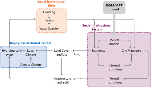
The Conceptual Framework
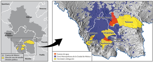
Case Study Map
|
The project is implemented in close collaboration with the National Autonomous University of Mexico City (UNAM) and local stakeholders. Three case studies of vulnerable regions within Mexico City characterize the complexity of residents’ experience of hazards and their response strategies. City-level analyses captures the institutional context of water resource decision-making and the mandates, intervention strategies and priorities of water resource managers in the city. A biophysical model simulates the impact of land use change and infrastructure modification on the city’s hydro-climatic system. Agent based modeling simulates the responses of residents and the city water authority to spatially differentiated hydroclimatic risk, in turn affecting the response of the hydro-climatic system. A geographic information system embedded in a multicriteria decision analysis framework (GIS-MCDA) permits the exploration of different scenarios of hazard response in a spatially explicit manner, facilitating decision-making concerning adaptation to changing hydro-climatic conditions. The project supports the interdisciplinary and cross-cultural training of graduate students affiliated with UNAM and Arizona State University, and through direct stakeholder involvement, aims to improve capacities for risk management in Mexico City. MEGADAPT aims to serve as a model for climate-change adaptation developing countries.
